3D MODEL

AVERAGE VEGETATION

The Station Fire ravaged Northern Los Angeles in the Fall of 2009. Residents of this part of California have grown accustomed to the dry, hot, fiery season that accompanies the Santa Ana winds, which in several cases has created minor brushfires that somewhat threatened their homes. However, the Station Fire was one of several behemoth blazes that came earlier than usual. It began earlier than the normal fire season, in August rather than September, before the Santa Ana winds came. Despite the lack of winds, the fires burned well into the month of October. It burned in the hilly, vegetated area northeast of the San Fernando Valley, north of the San Gabriel Valley, and south of the Antelope Valley, in Northern Los Angeles, and required the Governor to declare a state of emergency. It torched an area of 251 square miles and unfortunately took the lives of two firefighters. (cdfdata.fire.ca.gov, 2009).
At the beginning of the fire on August 31, there was just 1 injury, about 12,000 people threatened, 500 structures threatened, 53 structures destroyed, and 2 communication sites destroyed. By September 27, these numbers ballooned to 89 residences destroyed, 13 residences damaged, 26 commercial properties destroyed, 22 commercial properties damaged, 94 outbuildings destroyed, and 22 outbuildings damaged. In the midst of the battle against this blaze were 647 personnel, 5 helicopters, 27 fire engines, 14 hand crews, and 23 pieces of heavy equipment. (inciweb.org, 2009).
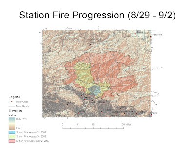
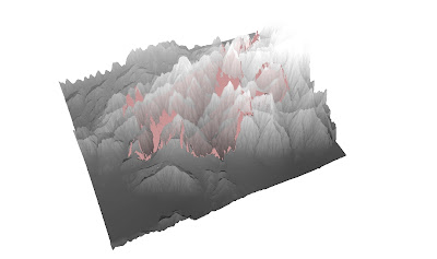
My analysis focuses on how a relatively minor brushfire can grow rapidly into a record-setting blaze. I am concerned with the spread of the fire in relation to the major population centers and major roadways in its proximity. First and foremost, my first map shows the progression of the Station Fire from August 29 to September 2, along with important information on elevation, major cities, and major roads. My second map is a 3D model of the fire, as seen from the southwest, that shows the elevation and fire perimeter on September 2 in more detail. We can see that the fire began in a relatively small area, the blue area north of La Canada-Flintridge. However, within 4 days it had spread west, north, and east to occupy a very large area that threatened several communities. In summary, the Station Fire severely threatened foothill communities including but not limited to La Crescenta, Montrose, La Canada-Flintridge, Altadena, and Acton. The GIS data used above was obtained from seamless.usgs.gov and gis.lacounty.gov.
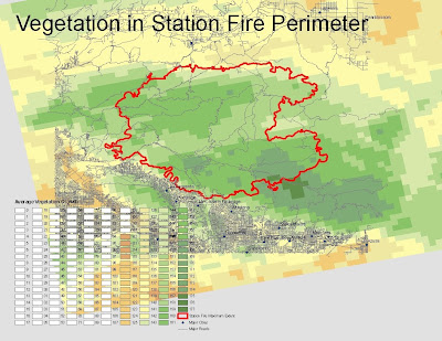
To fully understand the rapid spread of the Station Fire we must refer to GIS data. In addition to high temperatures and high winds, the seemingly uncontrollable spread of the fire can also be attributed to difficult logistics and an abundance of fuel. First and foremost, we can refer to the first and second maps to see that the hilly elevated area magnified the effect of gravity on the downhill spread of the fire. In addition, the sparse number of roads within the area made it impossible for firefighters to quickly and effectively create a perimeter before it had grown very large. To analyze the abundance of fuel we must refer to my third map, which shows the average vegetation in the affected area. It is clear to see that the perimeter of the fire as of September 2 encompassed a densely vegetated area in the middle of several population centers. The firefighters were only able to create a perimeter in areas were the average vegetation was significantly lower, in effect where the fire had run out of fuel.
All residents in the immediate foothills south of the fire were placed under mandatory evacuation. Many homes were within realistic reach of the blaze, and the ones that weren't were also enveloped by thick, unsafe smoke and ash. Several photographs showed firefighters bravely battling flames that had come within a few feet of backyards. In neighborhoods that were not so lucky, charred trees and homes were left in the wake of the fire. There is no doubt that this fire severely affected and changed the lives of residents in the threatened communities. (latimes.com, 2009)
BIBLIOGRAPHY
"2009 California wildfires." Wikipedia. 12 May 2010. 24 May 2010.
[http://en.wikipedia.org/wiki/2009_California_wildfires]
"InciWeb: Station Fire News Release." InciWeb. 10 November 2009. 24 May 2010.
[http://www.inciweb.org/incident/1856/]
"Station Fire Incident Information." Cal Fire. 16 October 2009. 24 May 2010.
[http://cdfdata.fire.ca.gov/incidents/incidents_details_info?incident_id=377]
"LA Now: Station Fire." LA Times. 9 November 2009. 24 May 2010.
[http://latimesblogs.latimes.com/lanow/2009/11/station-fire-still-burning-in-mt-wilson-root-system-bringing-out-more-firefighters.html]
No comments:
Post a Comment